The Scientific Phenomenon That Can Prevent Hurricanes During Peak Season
As those who live in and near the tropics know, mid-September is when "hurricane season" reaches its peak. Florida residents, for instance, often associate back-to-school reminders with the time to stock up on essentials, get the storm shutters ready, and go down the checklist of hurricane preparedness. But in 2025, the mid-September weather report was unexpectedly mild. Particularly strong westerly winds blew sand from the Sahara Desert into the Atlantic, curbing the conditions that give rise to hurricanes — much to the disappointment of school kids hoping for their classes to be canceled.
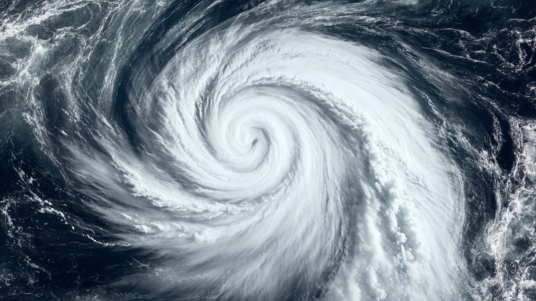
One of the first indications that something was unusual was when a potential hurricane suddenly shrunk to a minor blip on the radar on September 5. Throughout early September, meteorologists had been monitoring a tropical wave in the mid-Atlantic that had the characteristic warning signs of developing into a full-blown hurricane. Predictions had slotted the storm to potentially make landfall in the Caribbean and southeastern United States by September 15, but the storm's hot, moist air collided with dry air from the Sahara and virtually disappeared.
The suppression of hurricane formation isn't a new phenomenon, but it's still difficult to predict. Meteorologists rely on the climate data and instruments available to look for trends, so the perfect collision between dry, dusty Saharan winds and a tropical wave in the middle of the Atlantic can come as a surprise. But once the two masses do collide, the results are clear. Hurricanes form when warm air clusters into pockets over the ocean, evaporating surface water. Differences in temperature, humidity, and wind accelerate the process, helping the storm to grow in intensity. However, should the growing storm's warm, moist air meet with cool, dry air, the conditions effectively cancel each other out.
Hurricane suppression is a lucky roll of the dice
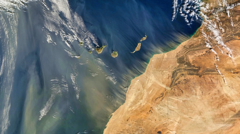
The Saharan wind's suppressive effect has been a factor in hurricane formation for millennia. There are several ways that the North African winds can affect hurricane formation when they blow across the Atlantic. For one, the sand and dust content can absorb sunlight before it can reach the surface of the ocean, which reduces the temperature of the surface water. Lower temperatures mean there is less energy available for potential hurricanes to grow.
Called the Saharan Air Layer (SAL), the dry, sandy air also tends to rise high above the moist surface layer, creating a barrier to hurricane-forming winds. Furthermore, the dust particles in the SAL may even act as condensation nuclei — points where water can condense, potentially turning into raindrops — and catalyze precipitation, stripping the hurricane of heat and energy. It's the same concept behind the use of silver iodide for artificial cloud seeding. (Though it should also be said that the creation of rain could also help fuel hurricanes; it depends on a few factors that scientists are still studying.)
However, although this year's peak hurricane season was suppressed by Saharan winds, it doesn't mean we can expect fewer hurricanes overall. In fact, hurricane season swung back into full force just a few weeks later with the regrowth of Hurricane Gabrielle near the Portuguese archipelago of the Azores. Indeed, human-induced climate change continues to increase the average intensity and frequency of hurricanes every year. Scientific agencies, such as NASA, are unanimous in this conclusion, and record-breaking Category 5 hurricanes, like Milton in 2024, confirm their predictions with every passing year.