The 4th Longest River In The World Is Right Here In The United States
When you think of the world's longest rivers, some of your first thoughts might be the Amazon and Nile rivers. The Nile River spans 4,132 miles, and it is considered the longest river in the world. Rounding out the top three longest rivers are the Amazon and Yangtze, which closely follow the Nile at 4,000 and 3,915 miles, respectively. It turns out that the world's fourth longest river system, however, is in the U.S.: the Mississippi-Missouri-Red Rock River.
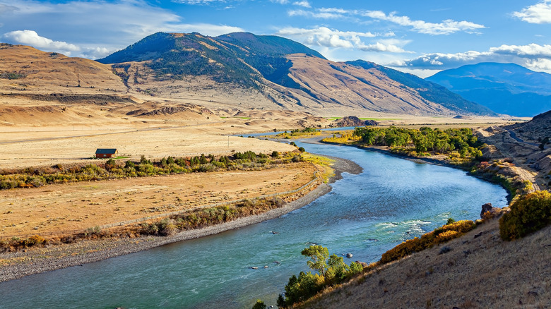
While the U.S. can boast having one of the world's longest rivers, there's also much more to the Mississippi-Missouri-Red Rock River besides its length. This river is arguably just as diverse as the country itself, as it runs through hills, valleys, and wetlands as it makes its way from the north and west down to join up with the spectacular sea species in the Gulf of Mexico. Aside from being a natural wonder, the river is also important for the economy, through things like recreational activities. While water activities like canoeing, boating, and kayaking might seem the most obvious, the riverbanks also offer numerous opportunities for biking, hiking, bird watching, camping, fishing, and more. Scientifically speaking, learning a bit more about the Mississippi-Missouri-Red Rock River could be vital to understanding the delicate nature of this system so humans can take action to protect the area for years to come.
In total, the river is nearly 4,000 miles long
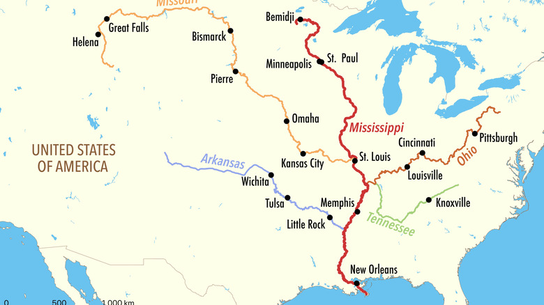
As the name indicates, the Mississippi-Missouri-Red Rock River includes three major rivers and related streams that overlap with one another. These include the Mississippi, Missouri, and Red Rock rivers. With a total estimated length of 3,710 miles, the Mississippi-Missouri-Red Rock River is almost as long as China's massive Yangtze River. It includes the Missouri River, which begins in Montana and includes the Red Rock River system. As the river makes its way to the central U.S., it meets up with the Mississippi River in St. Louis, Missouri (though, for reference, the Mississippi River actually begins in Minnesota).
Despite Mississippi being named first in this river system, the Missouri River is technically slightly longer. As the National Park Service notes, the Mississippi is considered the second longest river in the continent at 2,350 miles long when measured between Minnesota and the Gulf. The Missouri River, on the other hand, is a whopping 100 miles longer, and in fact flows for over 2,500 miles before meeting up with the Mississippi at their shared point in St. Louis. So if you've heard that the Mississippi River is the longest river in North America, this is true — but only when you consider the entire shared system with the Missouri River.
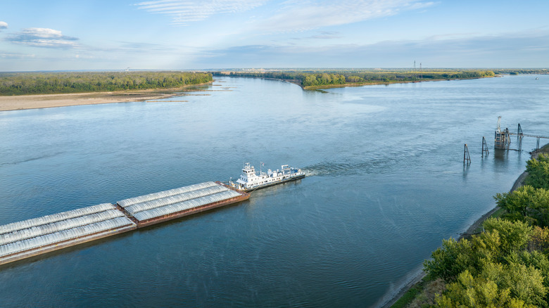
The Mississippi River is a vital area of transportation
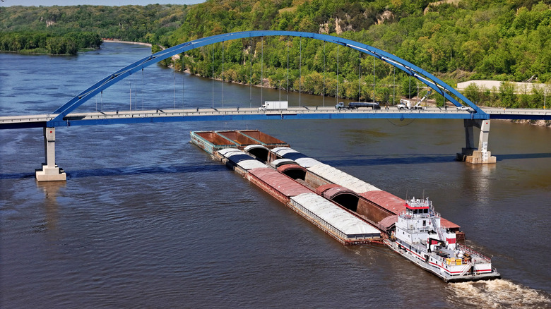
While the Mississippi River ranks second on the list of North America's longest rivers, the river is arguably the most important when considering transportation for both humans and wildlife. Indigenous tribes first used the river for transport before colonialists did the same. In particular, this portion of the Mississippi-Missouri-Red Rock River is considered vital for transporting goods throughout the country. Today, the Mississippi is considered a key mode of commercial transportation for iron, steel, coal, oil, and natural stone.
It's not just humans that use the Mississippi River portion of this system for transportation, though. In fact, it's also a crucial area for bird migrations between the Midwest and the Gulf shores. This area is nicknamed the "Mississippi Flyaway" and is considered the largest flyaway for birds in North America. At least 325 species of birds use this area along the river every fall and spring, including cranes, ducks, geese, and songbirds.
The river has a historic point of confluence
The St. Louis, Missouri, area is the point at which both major portions of the Mississippi-Missouri-Red Rock River system meet up, but the significance goes beyond geography. The area also has quite a bit of history, too. Not only was this point important from an agricultural standpoint for Indigenous tribes, but it's also thought to be the spot where Lewis and Clark shifted their historic expedition out towards the north and west. It's also nicknamed the Mississippi-Missouri Confluence, and it sits along the Lewis and Clark National Historic Trail run by the National Parks Service.
Before Lewis and Clark though, the Mississippi-Missouri Confluence was considered a trading hub for Indigenous tribes. Later, European settlers fought for control of the area for the rivers and the wetlands that surrounded them. Today, the area is now a popular spot for both history buffs and outdoor enthusiasts alike. It also houses Missouri's Edward "Ted" and Pat Jones-Confluence Point State Park, where you can hike, birdwatch, and fish as you witness the two longest North American rivers merge into one.
This historic and critical river is also endangered

Despite its economic importance and title for America's largest river, the Mississippi-Missouri-Red Rock River is also endangered. Unsurprisingly, the dangers posed to this river system are largely based on human activity. The direct use of the river for activities like transportation have certainly taken a toll on the water due to pollution. However, there's also some indirect human activities to consider as well. Nearby land development, pollution, agricultural runoff, and damming, are all examples of human activities that have impacted this extensive river, as have the effects of climate change. The Mississippi River was also deemed the most endangered river in the U.S. in 2025, per the non-profit American Rivers.
Unfortunately, the endangerment of the Mississippi-Missouri-Red Rock River poses numerous risks for humans and wildlife alike. Some portions of the river are experiencing erosion, which means less drinking water, fish, and recreational opportunities. On the flipside, parts of the Mississippi system are increasingly prone to flooding, which poses a risk to human life and property while also destroying delicate wetlands that so many species call home. Another issue is the loss of sediment that normally flows along both the Missouri and Mississippi Rivers, which then leads to more erosion problems along Louisiana's Gulf Coast.
This lengthy river is home to numerous types of wildlife
Overall, the problems plaguing the Mississippi-Missouri-Red Rock River can also pose issues for the numerous types of wildlife that live in and around the waters. This includes hundreds of varieties of birds, fish, mammals. Due to the length of the river system, you're even likely to witness different wildlife on the Midwestern end versus the southern portion.
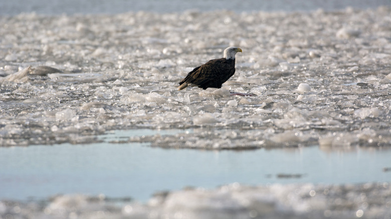
If you do happen to visit this vast river, keep your eye out for some of the wildlife that call this area home. The river is home to more than 100 types of fish, as well as mussels. You might also spot otters and beavers swimming in the water, or living along the banks of the river; the North American river otter was nearly extinct about a century ago, but has since made a comeback in the northern part of the river system thanks to changes in water quality. If you visit the upper Missouri portion, you might even get a chance to see rams and sheep that live in the wild, though all parts of the river system are valuable to deer, and elk, as well as numerous reptiles and amphibians. The river system is also home to several species of concern, and you can learn quite a few interesting facts about a number of different species, such as the lifespan of the American bald eagle, which may be seen along all portions from north to south. Overall, you can check out a list of the types of aquatic plants and animals in the Mississippi River ahead of your visit.
The Mississippi Delta is a critical part of the river system
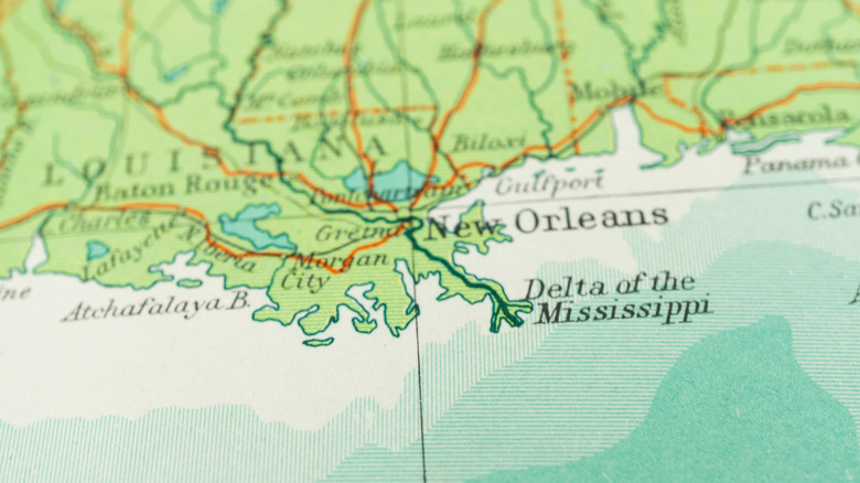
The overall length of the Mississippi-Missouri-Red Rock River and their starting points in the upper part of the U.S. certainly get the most attention. Still, it's also important to know about the bottom portion of the river well beyond the point of confluence. At the lower portion of this river system lies the critical Mississippi Delta, which also includes the point where it meets up with Gulf waters. The vast region includes areas between New Orleans, Louisiana, to Memphis, Tennessee. The Mississippi Delta acts as more than the endpoint of the Mississippi-Missouri-Red Rock River, though, as it serves critical environmental and economic purposes, too.
The Mississippi Delta was first home to Indigenous tribes, including the Chickasaw and Choctaw peoples who lived on the region's estimated 3 million acres. From an environmental standpoint, the Mississippi Delta is considered one of the nation's largest wetlands areas, but without the waters of the Mississippi River system, the Mississippi Delta and all of its offerings for the lifeforms that depend on it simply would not exist. At the same time, it's vital to consider the factors that affect the formation of a delta. Any disruptions in the river can also destroy the delta, which underscores the need to carefully manage human activities that might contribute to the problem, such as agriculture and housing.
The Mississippi Delta is considered to have significant economic importance, too. That's relevant to locals, but also to tourists who visit the area. The region contributes to an estimated $17 billion in tourism, as well as more than 300,000 related jobs.