

Scientists Are Ringing Alarms Bells For A Guaranteed 'Super El Nino'

El Niño is a climate pattern that manifests in the Pacific Ocean. It's characterized by weakening trade winds that create unusually warm waters in the Pacific that push back towards the Americas. This change in water temperature has worldwide climate repercussions, with some events worse than others. To that end, scientists from the World Meteorological Association, the National Weather Service's Climate Prediction Center, and other related organizations are all warning that the 2026–2027 El Niño we are currently experiencing is likely to turn into a "super El Niño," which has some defining characteristics and poses even more extreme weather events.
According to the National Oceanic and Atmospheric Administration (NOAA), an El Niño is officially declared when water temperatures along the equator in the Pacific Ocean are consistently 0.5 degrees Celsius (1 degree Fahrenheit) above average for several months in a row. A "super El Niño" still poses these same risks, except they are even more amplified. If temperatures along the equatorial Pacific start to tick up to 2 degrees Celsius (3.5 degrees Fahrenheit) above average, NOAA classifies the El Niño event as "very strong." While the term "super El Niño" is not an official one, it's important to know that this is the same as the "very strong" classification on NOAA's intensity scale. According to the Columbia Climate School, only three El Niño events have reached this "super" category since 1980.
What scientists are saying about the 2026-2027 El Niño event
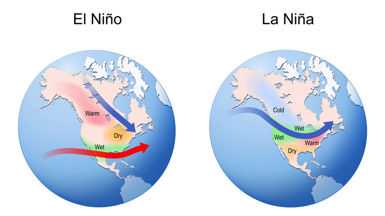
In a "normal" year, trade winds blow along the equator in the Pacific Ocean from east to west, and El Niño inevitably disrupts this flow. In the U.S., this results in warmer and drier conditions in the north, while the southern and Gulf Coast regions are more vulnerable to high precipitation and flooding. There are also fewer Atlantic hurricanes, due to interferences in hurricane formation, but increased hurricane activity in the eastern Pacific. On top of this, El Niño can adversely affect Pacific marine life due to warmer-than-normal waters. El Niño events occur every 2 to 5 years at varying intensities, says the National Centers for Environmental Information. They also tend to develop in the summer and continue through the following spring.
The stronger the event, the more likely some regions may experience even worse weather. Such is the case with a "super El Niño." First, the National Weather Service's Climate Prediction Center issued a statement in early September 2026 that forecast a 90% likelihood of a strong El Niño event during the fall and winter. Additionally, the World Meteorological Association also noted in September 2026 that the current El Niño event has about a 100% likelihood of lasting through February 2027. Notably, this is the first time that a super El Niño forecast has been so definitive among the World Meteorological Association's network of scientists, which underscores the seriousness and certainty of the phenomenon. Such forecasts all point to a strengthening El Niño.
Potential impacts of a 'super El Niño' in the US and beyond
As for the "super" part of this event, scientists predict that El Niño will increase in intensity and peak towards the end of 2026. Unfortunately, 2027 may not provide much relief, as the effects are expected to continue into the year. In fact, according to NOAA, El Niño events are generally worse in the winter in the Northern Hemisphere. For the U.S., this means a warm and dry winter in the north, with more rain and snow in the south. Areas along the West Coast may also be more susceptible to flooding events thanks to higher tides.
As for the global impacts, it's important to note that a super El Niño will affect various parts of the world differently. For example, while the southeastern U.S. and eastern portions of Africa experience higher-than-average levels of precipitation, drought conditions may develop in the north of South America, southern portions of Africa, and southeast Asia. Furthermore, some regions may experience more severe weather patterns than others. Overall, people should anticipate significant changes in temperature and rainfall that are out of the ordinary for their region.
Aside from the actual super El Niño itself, scientists also have another dire warning: This may in fact be one of the strongest (if not the strongest) El Niño on record. At the very least, some scientists are saying this ocean phenomenon may be the worst of its kind this century. While scientists continue to monitor the situation and make predictions, the exact outcomes are a not so certain.